Geolocate

Virle topographic map

Click on the map to display elevation.

About this map

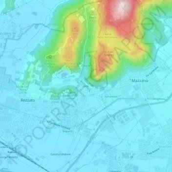
Name: Virle topographic map, elevation, terrain.

Location: Virle, Rezzato, Brescia, Lombardia, 25086, Italia (45.49751 10.31624 45.53751 10.35624)

Average elevation: 673 ft

Minimum elevation: 453 ft

Maximum elevation: 1,821 ft

Other topographic maps

Click on a map to view its topography, its elevation and its terrain.

Rezzato

Italia > Lombardia > Brescia > Rezzato

Average elevation: 577 ft

Gear up for your next adventure:

🏫Relief Map Kits - Hands-on tools for teaching landforms and elevation
🪄Magnetic Compass - Accurate compass for navigation
🚁Photography Drones - Capture stunning aerial views of landforms and topography
🔊Portable Camp Speaker - Music and alerts at camp
🪶Survival Guide Book - Expert advice for emergency preparedness

As an Amazon Associate, this site earns from qualifying purchases at no extra cost to you.