
Make a donation
Gear up for your next adventure:
As an Amazon Associate, this site earns from qualifying purchases at no extra cost to you.
Mont topographic map
Click on the map to display elevation.
Make a donation
Gear up for your next adventure:
As an Amazon Associate, this site earns from qualifying purchases at no extra cost to you.
About this map
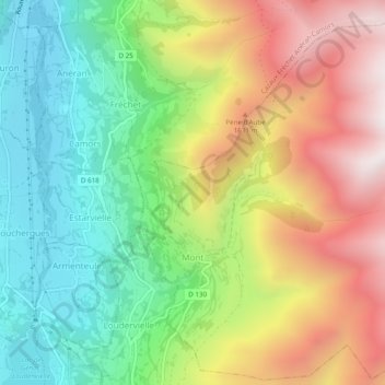
Name: Mont topographic map, elevation, terrain.
Average elevation: 4,383 ft
Minimum elevation: 2,966 ft
Maximum elevation: 6,306 ft
Make a donation
Gear up for your next adventure:
As an Amazon Associate, this site earns from qualifying purchases at no extra cost to you.
Other topographic maps
Click on a map to view its topography, its elevation and its terrain.
Luz-Saint-Sauveur
France > Occitania > Hautes Pyrenees > Luz-Saint-Sauveur > Luz-Saint-Sauveur
Average elevation: 3,396 ft
Make a donation
Gear up for your next adventure:
As an Amazon Associate, this site earns from qualifying purchases at no extra cost to you.
Make a donation
Gear up for your next adventure:
As an Amazon Associate, this site earns from qualifying purchases at no extra cost to you.
Cazaux-Debat
France > Occitania > Hautes Pyrenees > Cazaux-Fréchet-Anéran-Camors
Average elevation: 4,344 ft