
Make a donation
Gear up for your next adventure:
As an Amazon Associate, this site earns from qualifying purchases at no extra cost to you.
Hillary Step topographic map
Click on the map to display elevation.
Make a donation
Gear up for your next adventure:
As an Amazon Associate, this site earns from qualifying purchases at no extra cost to you.
Hillary Step
The step was named after Sir Edmund Hillary, who was the first known person, along with Tenzing Norgay, to scale it on the way to the summit during the 1953 British Mount Everest Expedition. Hillary and Tenzing first climbed the Hillary Step on 29 May 1953 by climbing the crack between the snow and the rock. Hillary reported that the snow on the step was harder than at lower elevation. Hillary wrote in 1953.
Make a donation
Gear up for your next adventure:
As an Amazon Associate, this site earns from qualifying purchases at no extra cost to you.
About this map
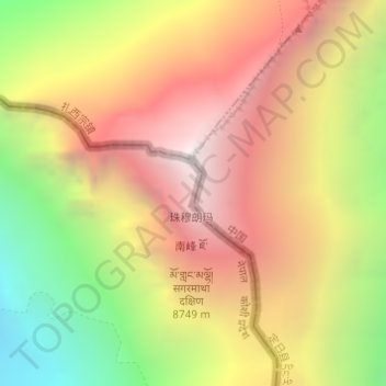
Name: Hillary Step topographic map, elevation, terrain.
Average elevation: 25,669 ft
Minimum elevation: 21,644 ft
Maximum elevation: 29,032 ft
Make a donation
Gear up for your next adventure:
As an Amazon Associate, this site earns from qualifying purchases at no extra cost to you.