
Zouk Mosbeh topographic map
Click on the map to display elevation.
Zouk Mosbeh
Zouk Mosbeh (Arabic: زوق مصبح) is a town and municipality in the Keserwan District of the Keserwan-Jbeil Governorate in Lebanon. It is located 12 kilometers north of Beirut. Zouk Mosbeh's average elevation is 170 meters above sea level and its total land area is 453 hectares. Its inhabitants are predominantly Maronite Catholics and Christians from other denominations. There are three schools in the town, one public and two private, which together enrolled a total of 4,633 students in 2005–2006. There were 167 businesses with over five employees operating in Zouk Mosbeh as of 2006.
About this map
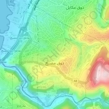
Name: Zouk Mosbeh topographic map, elevation, terrain.
Average elevation: 374 ft
Minimum elevation: 0 ft
Maximum elevation: 1,096 ft
Other topographic maps
Click on a map to view its topography, its elevation and its terrain.
Rayfoun
Lebanon > Keserwan-Jbeil Governorate
Rayfoun (Arabic: ريفون, romanized: Rayfūn; also spelled Reifun or Raifoun) is a village and municipality located in the Keserwan District of the Keserwan-Jbeil Governorate of Lebanon. The village is about 28 kilometres (17 mi) north of Beirut. It has an average elevation of 1,050 meters above sea level…
Average elevation: 3,202 ft
Mechmech
Lebanon > Keserwan-Jbeil Governorate
Mish Mish (Arabic: مشمش, also spelled Michmich) is a municipality in the Byblos District of Keserwan-Jbeil Governorate, Lebanon. It is 60 kilometers north of Beirut. Mish Mish has an average elevation of 1,200 meters above sea level and a total land area of 1,471 hectares. Its inhabitants are predominantly…
Average elevation: 3,881 ft
Faraya
Lebanon > Keserwan-Jbeil Governorate
Faraya (Arabic: فاريا) is a village and municipality in the Keserwan District of the Keserwan-Jbeil Governorate, Lebanon. It is located 46 kilometers north of Beirut. Elevation start from 1290 meters to 2000 meters above sea level and its total land area is 870 hectares. Faraya's inhabitants are…
Average elevation: 5,112 ft
Lassa
Lebanon > Keserwan-Jbeil Governorate
Lassa (Arabic: لاسا) is a municipality in the Byblos District of Keserwan-Jbeil Governorate, Lebanon. It is 90 kilometers north of Beirut. Lassa has an average elevation of 1,130 meters above sea level and a total land area of 739 hectares. The village contains one public school, which enrolled 15 students…
Average elevation: 4,314 ft
Lehfed
Lebanon > Keserwan-Jbeil Governorate
Lehfed (Arabic: لحفد, also known as Lihfid) is a municipality in the Byblos District of Keserwan-Jbeil Governorate, Lebanon. It is 55 kilometers north of Beirut. Lehfed has an average elevation of 1000 meters above sea level and a total land area of 542 hectares. There were three companies with more than…
Average elevation: 3,442 ft
Ehmej
Lebanon > Keserwan-Jbeil Governorate
Ehmej has a total land area of 1,742 hectares. The town's average elevation is 1,140 meters above sea level. Neighboring municipalities include Mish Mish to the west, Jaj to the north, Laqlouq and Mazraat es-Siyad to the east and Almat el-Shemaliat and Almat al-Janubiat to the south.
Average elevation: 3,947 ft
Sehaile
Lebanon > Keserwan-Jbeil Governorate
Sehaileh (Arabic: سهيلة; also spelled Seheileh or Shayleh) is a municipality in the Keserwan District of the Mount Lebanon Governorate in Lebanon. It is located 25 kilometers north of Beirut. Its average elevation is 550 meters above sea level and its total land area is 221 hectares. Sehaileh's…
Average elevation: 1,558 ft
Aaqoura
Lebanon > Keserwan-Jbeil Governorate
Aqoura (Arabic: عاقورة, also spelled Aaqoura, "Akoura") is a mountainous village in the Byblos District of Keserwan-Jbeil Governorate, Lebanon. It is lovated 68 kilometers north of Beirut. Aaqoura has an average elevation of 1,600 meters above sea level (between 1000 and 2189 m) and a total land area of…
Average elevation: 5,217 ft
Jaj
Lebanon > Keserwan-Jbeil Governorate
Jaj (Arabic: جاج, also spelled Jaje) is a mountainous village in the Byblos District of Keserwan-Jbeil Governorate, Lebanon. It is 68 kilometers north of Beirut. Jaj has an average elevation of 1,220 meters above sea level and a total land area of 1,174 hectares. Its inhabitants are predominantly Maronite…
Average elevation: 4,154 ft
Laqlouq
Lebanon > Keserwan-Jbeil Governorate
Laqlouq (Arabic: لقلوق), also spelled Laklouk and also known as ′Arab Laqlouq (Arabic: عرب القلوق) is a small mountainous village in mountainous area in the Byblos District of Keserwan-Jbeil Governorate, Lebanon. It is located 69 kilometers northeast of Beirut. Laqlouq has an average elevation…
Average elevation: 5,728 ft
Kfardebian
Lebanon > Keserwan-Jbeil Governorate
Kfardebian (Arabic: كفر دبيان; also spelled Kfar Dibiane and also known as Moucha'a Keserwan) is a municipality in the Keserwan District of the Keserwan-Jbeil Governorate in Lebanon. It is located 45 kilometers north of Beirut. Its average elevation is 1,220 meters above sea level and its total land…
Average elevation: 5,715 ft
Ashqout
Lebanon > Keserwan-Jbeil Governorate
Ashqout (Arabic: عشقوت; also spelled Ashkout, Achqout, `Ashqut) is a town and municipality in the Keserwan District of the Keserwan-Jbeil Governorate of Lebanon. It is located 31 kilometers north of Beirut. Ashqout's average elevation is 1,000 meters above sea level and its total land area is 588…
Average elevation: 3,409 ft
Faraya
Lebanon > Keserwan-Jbeil Governorate
Faraya (Arabic: فاريا) is a village and municipality in the Keserwan District of the Keserwan-Jbeil Governorate, Lebanon. It is located 46 kilometers north of Beirut. Elevation start from 1290 meters to 2000 meters above sea level and its total land area is 870 hectares. Faraya's inhabitants are…
Average elevation: 5,112 ft
Jaj
Lebanon > Keserwan-Jbeil Governorate
Jaj (Arabic: جاج, also spelled Jaje) is a mountainous village in the Byblos District of Keserwan-Jbeil Governorate, Lebanon. It is 68 kilometers north of Beirut. Jaj has an average elevation of 1,220 meters above sea level and a total land area of 1,174 hectares. Its inhabitants are predominantly Maronite…
Average elevation: 4,154 ft