Geolocate

Isla Mujeres topographic map

Click on the map to display elevation.

About this map

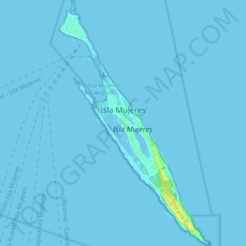
Name: Isla Mujeres topographic map, elevation, terrain.

Location: Isla Mujeres, Quintana Roo, 77402, Mexico (21.20154 -86.75277 21.26548 -86.71065)

Average elevation: 0 ft

Minimum elevation: -7 ft

Maximum elevation: 79 ft

Gear up for your next adventure:

🛠️Outdoor Gear Repair Kit - Essential tools to fix gear on the trail
🕶️Glacier Sunglasses - Side shields to protect eyes from high-altitude snow glare
📚Navigation Handbooks - Master the art of reading topographic maps and using a compass
😴Insulated Sleeping Pads - Compact and warm pads for high-elevation camping
🔥Plasma Lighters - Windproof lighters that work in any weather condition

As an Amazon Associate, this site earns from qualifying purchases at no extra cost to you.