
Make a donation
Gear up for your next adventure:
As an Amazon Associate, this site earns from qualifying purchases at no extra cost to you.
Candoni topographic map
Click on the map to display elevation.
Make a donation
Gear up for your next adventure:
As an Amazon Associate, this site earns from qualifying purchases at no extra cost to you.
Candoni
Candoni is located 130 kilometres (81 mi) south-south-west of the provincial capital, Bacolod. It is approximately four hour drive from Bacolod City aboard a public utility vehicle and about two hours and 45 minutes on a private car. From Bacolod City, buses are available at Bacolod South Terminal. From Kabankalan City, one can take the public utility jeepneys or buses going to this town. Candoni is the third town with highest elevation in Negros Occidental after Salvador Benedicto and San Carlos City.
Make a donation
Gear up for your next adventure:
As an Amazon Associate, this site earns from qualifying purchases at no extra cost to you.
About this map
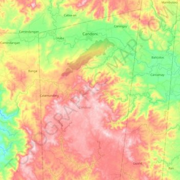
Name: Candoni topographic map, elevation, terrain.
Location: Candoni, Negros Occidental, Western Visayas, 6110, Philippines (9.66385 122.58368 9.85855 122.70091)
Average elevation: 1,010 ft
Minimum elevation: 174 ft
Maximum elevation: 1,785 ft
Make a donation
Gear up for your next adventure:
As an Amazon Associate, this site earns from qualifying purchases at no extra cost to you.
Other topographic maps
Click on a map to view its topography, its elevation and its terrain.
Make a donation
Gear up for your next adventure:
As an Amazon Associate, this site earns from qualifying purchases at no extra cost to you.
Make a donation
Gear up for your next adventure:
As an Amazon Associate, this site earns from qualifying purchases at no extra cost to you.
Make a donation
Gear up for your next adventure:
As an Amazon Associate, this site earns from qualifying purchases at no extra cost to you.
Salvador Benedicto
Philippines > Negros Occidental > Salvador Benedicto > Salvador Benedicto
Average elevation: 2,251 ft