Geolocate

Neuhof topographic map

Click on the map to display elevation.

About this map

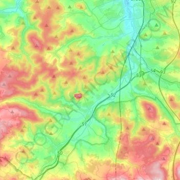
Name: Neuhof topographic map, elevation, terrain.

Location: Neuhof, Landkreis Fulda, Hesse, 36119, Germany (50.42762 9.45029 50.51813 9.70002)

Average elevation: 1,178 ft

Minimum elevation: 810 ft

Maximum elevation: 1,745 ft

Other topographic maps

Click on a map to view its topography, its elevation and its terrain.

Mühlhansemühle

Germany > Hesse > Landkreis Fulda > Mittelkalbach

Average elevation: 1,247 ft

Milseburg

Germany > Hesse > Landkreis Fulda

The Milseburg is an extinct volcano and at 835 metres (2,740 ft) above sea level the second highest elevation in the Hessian part of the Rhön Mountains, Germany. The hill is located east of Fulda, near the villages of Kleinsassen and Danzwiesen. It is a popular destination for hikers and bikers.…

Average elevation: 2,031 ft

Branders

Germany > Hesse > Landkreis Fulda > Buchenau

Average elevation: 1,129 ft

Erlenhof

Germany > Hesse > Landkreis Fulda

Average elevation: 1,004 ft

Gear up for your next adventure:

📱Heavy-Duty Phone Cases - Drop-proof and waterproof protection for outdoor navigation
🌄Hiking Binoculars - Compact binoculars for scenic views and trail spotting
🔦Powerful Headlamps - Ultra-bright hands-free lighting for night navigation
🛡️Insect Repellent - Protection against bugs during outdoor activities
🪶Camp Gear Gift Set - Perfect gift bundle for outdoor fans

As an Amazon Associate, this site earns from qualifying purchases at no extra cost to you.