
Make a donation
Gear up for your next adventure:
As an Amazon Associate, this site earns from qualifying purchases at no extra cost to you.
Weston topographic map
Click on the map to display elevation.
Make a donation
Gear up for your next adventure:
As an Amazon Associate, this site earns from qualifying purchases at no extra cost to you.
Weston
Development of country estates in Weston began on a small scale in the 1860s and was widespread by 1900. Wealthy businessmen were attracted to Weston by its convenience to Boston, quiet country atmosphere, and low taxes, as well as the beauty of the area and that same rocky topography that in earlier years had proved unsuitable for farming. By the turn of the century, Weston was described as a "country town of residences of the first class."
Make a donation
Gear up for your next adventure:
As an Amazon Associate, this site earns from qualifying purchases at no extra cost to you.
About this map
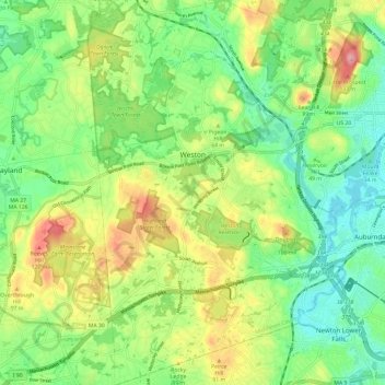
Name: Weston topographic map, elevation, terrain.
Average elevation: 184 ft
Minimum elevation: 23 ft
Maximum elevation: 449 ft
Middlesex County trails, hiking, mountain biking, running and outdoor activities
Make a donation
Gear up for your next adventure:
As an Amazon Associate, this site earns from qualifying purchases at no extra cost to you.
Other topographic maps
Click on a map to view its topography, its elevation and its terrain.
Make a donation
Gear up for your next adventure:
As an Amazon Associate, this site earns from qualifying purchases at no extra cost to you.
Make a donation
Gear up for your next adventure:
As an Amazon Associate, this site earns from qualifying purchases at no extra cost to you.
Make a donation
Gear up for your next adventure:
As an Amazon Associate, this site earns from qualifying purchases at no extra cost to you.
Framingham Center
United States > Massachusetts > Middlesex County > Framingham
Average elevation: 190 ft
Make a donation
Gear up for your next adventure:
As an Amazon Associate, this site earns from qualifying purchases at no extra cost to you.
Medford Hillside
United States > Massachusetts > Middlesex County > Medford > West Medford
Average elevation: 43 ft
North Chelmsford
United States > Massachusetts > Middlesex County > Chelmsford
Average elevation: 135 ft
Winchester Highlands
United States > Massachusetts > Middlesex County > Winchester
Average elevation: 115 ft
Make a donation
Gear up for your next adventure:
As an Amazon Associate, this site earns from qualifying purchases at no extra cost to you.
Melrose Highlands
United States > Massachusetts > Middlesex County > Melrose
Average elevation: 125 ft
Susan Lawerence Land
United States > Massachusetts > Middlesex County > Stow
Average elevation: 246 ft
Make a donation
Gear up for your next adventure:
As an Amazon Associate, this site earns from qualifying purchases at no extra cost to you.
Make a donation
Gear up for your next adventure:
As an Amazon Associate, this site earns from qualifying purchases at no extra cost to you.
Make a donation
Gear up for your next adventure:
As an Amazon Associate, this site earns from qualifying purchases at no extra cost to you.
Make a donation
Gear up for your next adventure:
As an Amazon Associate, this site earns from qualifying purchases at no extra cost to you.
Make a donation
Gear up for your next adventure:
As an Amazon Associate, this site earns from qualifying purchases at no extra cost to you.
Hobbs Road
United States > Massachusetts > Middlesex County > Wayland > Cochituate
Average elevation: 217 ft
Make a donation
Gear up for your next adventure:
As an Amazon Associate, this site earns from qualifying purchases at no extra cost to you.
Camp Kiwanis
United States > Massachusetts > Middlesex County > Tyngsborough
Average elevation: 217 ft
Arlington Heights
United States > Massachusetts > Middlesex County > Arlington
Average elevation: 190 ft
Make a donation
Gear up for your next adventure:
As an Amazon Associate, this site earns from qualifying purchases at no extra cost to you.
North Chelmsford
United States > Massachusetts > Middlesex County > Chelmsford
Average elevation: 135 ft
Make a donation
Gear up for your next adventure:
As an Amazon Associate, this site earns from qualifying purchases at no extra cost to you.
Cambridge
United States > Massachusetts > Middlesex County > Cambridge
Cambridge obtains water from Hobbs Brook (in Lincoln and Waltham) and Stony Brook (Waltham and Weston), as well as an emergency connection to the Massachusetts Water Resources Authority. The city owns over 1,200 acres (486 ha) of land in other towns that includes these reservoirs and portions of their…
Average elevation: 102 ft
Make a donation
Gear up for your next adventure:
As an Amazon Associate, this site earns from qualifying purchases at no extra cost to you.
Glendale
United States > Massachusetts > Middlesex County > Everett > Glendale
Average elevation: 46 ft
Make a donation
Gear up for your next adventure:
As an Amazon Associate, this site earns from qualifying purchases at no extra cost to you.
East Acton
United States > Massachusetts > Middlesex County > Acton > East Acton
Average elevation: 174 ft
Weston Station
United States > Massachusetts > Middlesex County > Weston > Weston Station
Average elevation: 180 ft
Make a donation
Gear up for your next adventure:
As an Amazon Associate, this site earns from qualifying purchases at no extra cost to you.