Geolocate

Amherst topographic map

Click on the map to display elevation.

About this map

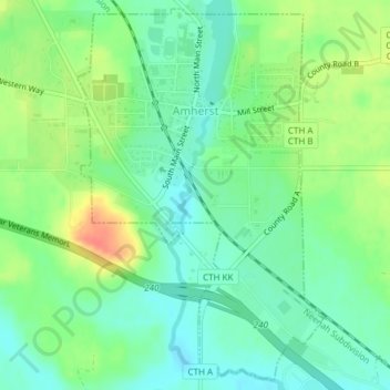
Name: Amherst topographic map, elevation, terrain.

Location: Amherst, Portage County, Wisconsin, United States (44.43197 -89.29612 44.45774 -89.27216)

Average elevation: 1,076 ft

Minimum elevation: 1,017 ft

Maximum elevation: 1,178 ft

Portage County trails, hiking, mountain biking, running and outdoor activities

Other topographic maps

Click on a map to view its topography, its elevation and its terrain.

Custer

United States > Wisconsin > Portage County

Average elevation: 1,178 ft

Heffron

United States > Wisconsin > Portage County

Average elevation: 1,145 ft

Polonia

United States > Wisconsin > Portage County

Average elevation: 1,207 ft

Peru

United States > Wisconsin > Portage County

Average elevation: 1,138 ft

Bancroft

United States > Wisconsin > Portage County

Average elevation: 1,089 ft

Dopp

United States > Wisconsin > Portage County

Average elevation: 1,027 ft

Gear up for your next adventure:

🚪Portable Camp Chair - Foldable chair for comfort at camp
🔪Outdoor Multitools - Essential survival tools for gear repair and field use
🪑Ultralight Camp Chairs - Portable seating for resting after a long day of mapping
🧭Pro Hiking Compasses - High-accuracy liquid-filled compasses for topographic orientation
👖Convertible Hiking Pants - Versatile zip-off pants for changing altitudes and temperatures

As an Amazon Associate, this site earns from qualifying purchases at no extra cost to you.