
l'Ametlla de Mar topographic map
Interactive map
Click on the map to display elevation.
About this map
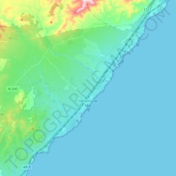
Name: l'Ametlla de Mar topographic map, elevation, terrain.
Location: l'Ametlla de Mar, Baix Ebre, Tarragona, Catalonia, 43860, Spain (40.84596 0.68465 40.94408 0.85736)
Average elevation: 203 ft
Minimum elevation: -3 ft
Maximum elevation: 1,555 ft
Other topographic maps
Click on a map to view its topography, its elevation and its terrain.
Boca de Foix
Spain > Catalonia > Baix Ebre > Tivenys
Boca de Foix, Tivenys, Baix Ebre, Tarragona, Catalonia, 43511, Spain
Average elevation: 1,243 ft