Geolocate

Hukay topographic map

Click on the map to display elevation.

About this map

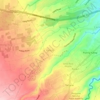
Name: Hukay topographic map, elevation, terrain.

Location: Hukay, Silang, Cavite, Calabarzon, 4118, Philippines (14.19687 120.99510 14.23687 121.03510)

Average elevation: 902 ft

Minimum elevation: 522 ft

Maximum elevation: 1,201 ft

Other topographic maps

Click on a map to view its topography, its elevation and its terrain.

Carmen

Philippines > Cavite > Silang

Average elevation: 564 ft

Carmen

Philippines > Cavite > Silang

Average elevation: 564 ft

Gear up for your next adventure:

☀️Outdoor Sunscreen - High protection sunscreen for outdoor activities
🚗GPS Dash Cams - Record your scenic drives through mountain passes and canyons
🪶Thermal Camp Blanket - Extra warmth for cold nights
🏔️Mountain Trail Maps - High‑detail maps for popular peaks
🔊Portable Camp Speaker - Music and alerts at camp

As an Amazon Associate, this site earns from qualifying purchases at no extra cost to you.