
Thank you for supporting this site ❤️
Make a donation
Make a donation
Gear up for your next adventure:
As an Amazon Associate, this site earns from qualifying purchases at no extra cost to you.
Castillejos topographic map
Click on the map to display elevation.
Thank you for supporting this site ❤️
Make a donation
Make a donation
Gear up for your next adventure:
As an Amazon Associate, this site earns from qualifying purchases at no extra cost to you.
About this map
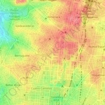
Name: Castillejos topographic map, elevation, terrain.
Location: Castillejos, Tetuán, Madrid, Community of Madrid, 28020, Spain (40.45613 -3.70146 40.46593 -3.68930)
Average elevation: 2,349 ft
Minimum elevation: 2,198 ft
Maximum elevation: 2,441 ft
Thank you for supporting this site ❤️
Make a donation
Make a donation
Gear up for your next adventure:
As an Amazon Associate, this site earns from qualifying purchases at no extra cost to you.
Other topographic maps
Click on a map to view its topography, its elevation and its terrain.