
Make a donation
Gear up for your next adventure:
As an Amazon Associate, this site earns from qualifying purchases at no extra cost to you.
Cherokee Garden topographic map
Click on the map to display elevation.
Make a donation
Gear up for your next adventure:
As an Amazon Associate, this site earns from qualifying purchases at no extra cost to you.
About this map
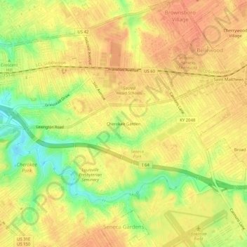
Name: Cherokee Garden topographic map, elevation, terrain.
Average elevation: 538 ft
Minimum elevation: 443 ft
Maximum elevation: 581 ft
Jefferson County trails, hiking, mountain biking, running and outdoor activities
Make a donation
Gear up for your next adventure:
As an Amazon Associate, this site earns from qualifying purchases at no extra cost to you.
Other topographic maps
Click on a map to view its topography, its elevation and its terrain.
Falls of the Ohio State Park
United States > Kentucky > Jefferson County > Louisville
Average elevation: 443 ft
Jefferson Memorial Forest
United States > Kentucky > Jefferson County > Louisville
Average elevation: 538 ft
Make a donation
Gear up for your next adventure:
As an Amazon Associate, this site earns from qualifying purchases at no extra cost to you.
Mirror Lakes
United States > Kentucky > Jefferson County > Louisville > Hopewell
Average elevation: 650 ft