
Make a donation
Gear up for your next adventure:
As an Amazon Associate, this site earns from qualifying purchases at no extra cost to you.
Rönne topographic map
Click on the map to display elevation.
Make a donation
Gear up for your next adventure:
As an Amazon Associate, this site earns from qualifying purchases at no extra cost to you.
About this map
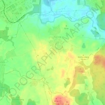
Name: Rönne topographic map, elevation, terrain.
Location: Rönne, Kiel, Schleswig-Holstein, Deutschland (54.25240 10.15393 54.27526 10.20247)
Average elevation: 164 ft
Minimum elevation: 85 ft
Maximum elevation: 259 ft
Make a donation
Gear up for your next adventure:
As an Amazon Associate, this site earns from qualifying purchases at no extra cost to you.
Other topographic maps
Click on a map to view its topography, its elevation and its terrain.
Kiel
Deutschland > Schleswig-Holstein > Kiel
Der reine Güterumschlag, der zum großen Teil im Kieler Ostuferhafen stattfindet, spielt dagegen deutschlandweit eine eher untergeordnete Rolle. Im Jahr 2010 wurden in den Kieler Häfen 5,8 Millionen t Güter umgeschlagen, 2011 lag der Wert mit 6,29 Mio. t um 8,5 % höher, 2012 wurden mehr als 6,3 Mio. t…
Average elevation: 79 ft
Make a donation
Gear up for your next adventure:
As an Amazon Associate, this site earns from qualifying purchases at no extra cost to you.