
Kamberg topographic map
Click on the map to display elevation.
About this map
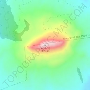
Name: Kamberg topographic map, elevation, terrain.
Average elevation: 5,801 ft
Minimum elevation: 5,344 ft
Maximum elevation: 6,841 ft
Other topographic maps
Click on a map to view its topography, its elevation and its terrain.
uMngeni
South Africa > KwaZulu-Natal > uMgungundlovu District Municipality > uMgeni Local Municipality
Average elevation: 4,813 ft
uMngeni River
South Africa > KwaZulu-Natal > uMgungundlovu District Municipality > uMgeni Local Municipality > Howick
Average elevation: 3,399 ft
Mpofana
South Africa > KwaZulu-Natal > uMgungundlovu District Municipality > uMgeni Local Municipality
Average elevation: 4,370 ft
uMngeni River
South Africa > KwaZulu-Natal > uMgungundlovu District Municipality > uMgeni Local Municipality > Howick
Average elevation: 3,415 ft
uMngeni
South Africa > KwaZulu-Natal > uMgungundlovu District Municipality > uMgeni Local Municipality
Average elevation: 3,553 ft