
Make a donation
Gear up for your next adventure:
As an Amazon Associate, this site earns from qualifying purchases at no extra cost to you.
Helling topographic map
Click on the map to display elevation.
Make a donation
Gear up for your next adventure:
As an Amazon Associate, this site earns from qualifying purchases at no extra cost to you.
About this map
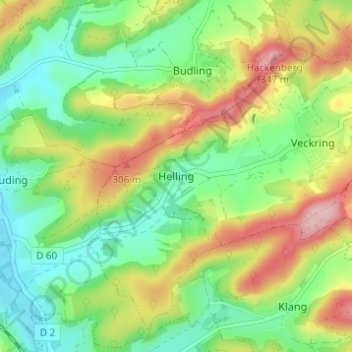
Name: Helling topographic map, elevation, terrain.
Average elevation: 797 ft
Minimum elevation: 571 ft
Maximum elevation: 1,148 ft
Make a donation
Gear up for your next adventure:
As an Amazon Associate, this site earns from qualifying purchases at no extra cost to you.
Other topographic maps
Click on a map to view its topography, its elevation and its terrain.
Make a donation
Gear up for your next adventure:
As an Amazon Associate, this site earns from qualifying purchases at no extra cost to you.
Make a donation
Gear up for your next adventure:
As an Amazon Associate, this site earns from qualifying purchases at no extra cost to you.
Make a donation
Gear up for your next adventure:
As an Amazon Associate, this site earns from qualifying purchases at no extra cost to you.
Make a donation
Gear up for your next adventure:
As an Amazon Associate, this site earns from qualifying purchases at no extra cost to you.
Make a donation
Gear up for your next adventure:
As an Amazon Associate, this site earns from qualifying purchases at no extra cost to you.
Delme
Delme is located 30 km to the southeast of Metz and 27 km northeast of Nancy. Next communes: Tincry and Prévocourt in the northeast, Viviers in the east, Donjeux, Laneuveville-en-Saulnois and Oriocourt in the southeast, Lemoncourt in the south, Puzieux, Alaincourt-la-Côte and Xocourt in the northwest. Its…
Average elevation: 801 ft