
Make a donation
Gear up for your next adventure:
As an Amazon Associate, this site earns from qualifying purchases at no extra cost to you.
Cheriton topographic map
Click on the map to display elevation.
Make a donation
Gear up for your next adventure:
As an Amazon Associate, this site earns from qualifying purchases at no extra cost to you.
About this map
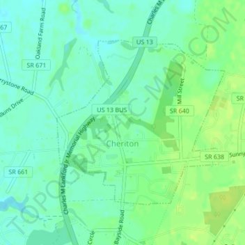
Name: Cheriton topographic map, elevation, terrain.
Location: Cheriton, Northampton County, Virginia, 23316, United States (37.28280 -75.98051 37.30096 -75.95714)
Average elevation: 23 ft
Minimum elevation: 0 ft
Maximum elevation: 46 ft
Northampton County trails, hiking, mountain biking, running and outdoor activities
Make a donation
Gear up for your next adventure:
As an Amazon Associate, this site earns from qualifying purchases at no extra cost to you.
Other topographic maps
Click on a map to view its topography, its elevation and its terrain.
Kiptopeke State Park
United States > Virginia > Northampton County > Kiptopeke
Average elevation: 20 ft
Make a donation
Gear up for your next adventure:
As an Amazon Associate, this site earns from qualifying purchases at no extra cost to you.
Make a donation
Gear up for your next adventure:
As an Amazon Associate, this site earns from qualifying purchases at no extra cost to you.