Geolocate

Merriam topographic map

Click on the map to display elevation.

About this map

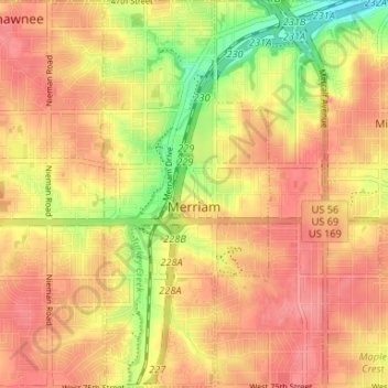
Name: Merriam topographic map, elevation, terrain.

Location: Merriam, Johnson County, Kansas, United States (38.99297 -94.70580 39.04407 -94.67690)

Average elevation: 1,004 ft

Minimum elevation: 840 ft

Maximum elevation: 1,096 ft

Johnson County trails, hiking, mountain biking, running and outdoor activities

Other topographic maps

Click on a map to view its topography, its elevation and its terrain.

Aubry

United States > Kansas > Johnson County

Average elevation: 1,066 ft

Kill Creek Park

United States > Kansas > Johnson County > De Soto

Average elevation: 902 ft

Prairie Highlands

United States > Kansas > Johnson County > Olathe

Average elevation: 1,030 ft

Olathe

United States > Kansas > Johnson County > Olathe

Average elevation: 991 ft

Lenexa

United States > Kansas > Johnson County > Lenexa

Average elevation: 951 ft

Gear up for your next adventure:

🔌Solar Panel Charger - Charge gear sustainably outdoors
🚗GPS Dash Cams - Record your scenic drives through mountain passes and canyons
🔦Compact Flashlight - Reliable flashlight for emergencies
🔥Camping Stove - Portable stove for camping and backcountry cooking
🛡️Bear Spray Outdoor - Protection in bear country hikes

As an Amazon Associate, this site earns from qualifying purchases at no extra cost to you.