Geolocate

Porirua topographic map

Click on the map to display elevation.

About this map

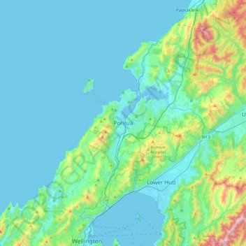
Name: Porirua topographic map, elevation, terrain.

Location: Porirua, Porirua City, Wellington, 5022, New Zealand (-41.29542 174.67978 -40.97542 174.99978)

Average elevation: 377 ft

Minimum elevation: 0 ft

Maximum elevation: 2,575 ft

Other topographic maps

Click on a map to view its topography, its elevation and its terrain.

Mana Island

New Zealand > Wellington > Porirua City > Porirua

Average elevation: 52 ft

Gear up for your next adventure:

Backpacking Tents - Weight-optimized shelters for multi-day topographic surveys
🚑Emergency Bivvies - Heat-reflective sleeping bags for survival situations
💧Water Filtration Bottles - Safely drink from streams and lakes while exploring
🧦Merino Wool Socks - Moisture-wicking, blister-preventing socks for long treks
🔪Outdoor Multitools - Essential survival tools for gear repair and field use

As an Amazon Associate, this site earns from qualifying purchases at no extra cost to you.