
Make a donation
Gear up for your next adventure:
As an Amazon Associate, this site earns from qualifying purchases at no extra cost to you.
Šternberk topographic map
Click on the map to display elevation.
Make a donation
Gear up for your next adventure:
As an Amazon Associate, this site earns from qualifying purchases at no extra cost to you.
Šternberk
Šternberk lies on the border of two geomorphological units. Most of the territory belongs to the Nízký Jeseník mountain range within the Eastern Sudetes. Eastern part of the town lies in the Upper Morava Valley. The highest point of the municipal territory is the hill Vysoká Roudná with an elevation of 660 metres (2,170 ft).
Make a donation
Gear up for your next adventure:
As an Amazon Associate, this site earns from qualifying purchases at no extra cost to you.
About this map
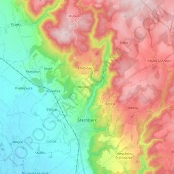
Name: Šternberk topographic map, elevation, terrain.
Average elevation: 1,381 ft
Minimum elevation: 725 ft
Maximum elevation: 2,218 ft
Make a donation
Gear up for your next adventure:
As an Amazon Associate, this site earns from qualifying purchases at no extra cost to you.
Other topographic maps
Click on a map to view its topography, its elevation and its terrain.
Make a donation
Gear up for your next adventure:
As an Amazon Associate, this site earns from qualifying purchases at no extra cost to you.