
Make a donation
Gear up for your next adventure:
As an Amazon Associate, this site earns from qualifying purchases at no extra cost to you.
Dorve topographic map
Click on the map to display elevation.
Make a donation
Gear up for your next adventure:
As an Amazon Associate, this site earns from qualifying purchases at no extra cost to you.
About this map
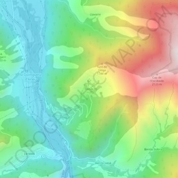
Name: Dorve topographic map, elevation, terrain.
Average elevation: 4,465 ft
Minimum elevation: 2,989 ft
Maximum elevation: 7,257 ft
Make a donation
Gear up for your next adventure:
As an Amazon Associate, this site earns from qualifying purchases at no extra cost to you.
Other topographic maps
Click on a map to view its topography, its elevation and its terrain.
Espot
Spanje > Catalonië > Pallars Sobirà
De gemeente heeft een oppervlakte van 97 km² en telt 361 inwoners (1 januari 2016). De plaats ligt op een hoogte van ongeveer 1200 meter, aan de oostkant van het Nationaal park Aigüestortes i Estany de Sant Maurici.
Average elevation: 6,125 ft