Geolocate

Ferretti topographic map

Click on the map to display elevation.

About this map

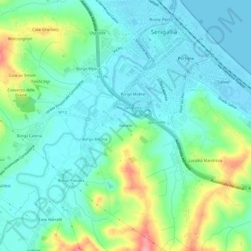
Name: Ferretti topographic map, elevation, terrain.

Location: Ferretti, Senigallia, Ancona, Marche, 60019, Italia (43.67998 13.18952 43.71998 13.22952)

Average elevation: 105 ft

Minimum elevation: -7 ft

Maximum elevation: 400 ft

Gear up for your next adventure:

🔦LED Headlamp - Bright and durable LED headlamp for night navigation
🏕️Tent Footprint - Protect your tent base from wear
🧭Hiking Compass - Precision compass for reliable navigation in the wilderness
📚USA Hiking Guide Books - Top trail guides and map books
🧯Emergency Survival Kit - All‑in‑one survival essentials for the backcountry

As an Amazon Associate, this site earns from qualifying purchases at no extra cost to you.