
Make a donation
Gear up for your next adventure:
As an Amazon Associate, this site earns from qualifying purchases at no extra cost to you.
Jackson topographic map
Click on the map to display elevation.
Make a donation
Gear up for your next adventure:
As an Amazon Associate, this site earns from qualifying purchases at no extra cost to you.
Jackson
The topography is hilly, with high points at over 1,200 feet (370 m) on Mount Harris and other peaks to the north, remnants of the Appalachian chain. The land area of the township is mostly forested, primarily a second growth northern mixed hardwood forest dominated by ash, poplar, oak, maple, pine, cedar, spruce, tamarack (larch) and hemlock. Forestry and livestock farming are the largest land uses, with hay the most common crop, corn silage the second most common. There are areas that have never been managed or cultivated, particularly bogs and remnant primeval forest in which large pine, hemlock and spruce trees predominate.
Make a donation
Gear up for your next adventure:
As an Amazon Associate, this site earns from qualifying purchases at no extra cost to you.
About this map
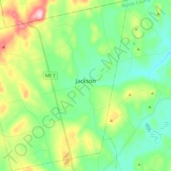
Name: Jackson topographic map, elevation, terrain.
Location: Jackson, Waldo County, Maine, United States (44.56493 -69.20425 44.65932 -69.08863)
Average elevation: 515 ft
Minimum elevation: 230 ft
Maximum elevation: 1,181 ft
Waldo County trails, hiking, mountain biking, running and outdoor activities
Make a donation
Gear up for your next adventure:
As an Amazon Associate, this site earns from qualifying purchases at no extra cost to you.
Other topographic maps
Click on a map to view its topography, its elevation and its terrain.