
Make a donation
Gear up for your next adventure:
As an Amazon Associate, this site earns from qualifying purchases at no extra cost to you.
Kisangani topographic map
Click on the map to display elevation.
Make a donation
Gear up for your next adventure:
As an Amazon Associate, this site earns from qualifying purchases at no extra cost to you.
Kisangani
Kisangani is at the center of the Tshopo, and is bordered by Banalia Territory to the north, Ubundu and Opala territories to the south, Isangi to the west, and Bafwasende municipalities to the east. The city of Kisangani lies 324 km from Buta, 572 kilometres (355 mi) from Isiro, 696 kilometres (432 mi) from Bunia and 2,912 kilometres (1,809 mi) from Kinshasa. The city's topography is diverse, with a population density of 229 residents per km2. It sits in the midst of the vast and isolated Congo Basin, the second largest tropical woodlands on the planet. It is located at 0° 31' north latitude (57 km from the equator), 25° 11' east longitude from the meridian of Greenwich and 396 metres (1,299 ft) above sea level. The altitude fluctuates across different plateaus, with the Arabized plateau in the southeast and the medical plateau to the west ranging from 37 to 45 meters, and the Boyoma plateau in the northeast reaching up to 46 meters. The National Institute of Statistics (INS) reports that Kisangani covers a total area of approximately 1,910 square kilometers.
Make a donation
Gear up for your next adventure:
As an Amazon Associate, this site earns from qualifying purchases at no extra cost to you.
About this map
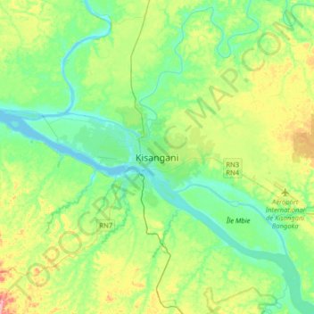
Name: Kisangani topographic map, elevation, terrain.
Location: Kisangani, Tshopo, Democratic Republic of the Congo (0.35840 25.04573 0.67840 25.36573)
Average elevation: 1,362 ft
Minimum elevation: 1,240 ft
Maximum elevation: 1,650 ft
Make a donation
Gear up for your next adventure:
As an Amazon Associate, this site earns from qualifying purchases at no extra cost to you.