
Thank you for supporting this site ❤️
Make a donation
Make a donation
Gear up for your next adventure:
As an Amazon Associate, this site earns from qualifying purchases at no extra cost to you.
Kuchinda topographic map
Click on the map to display elevation.
Thank you for supporting this site ❤️
Make a donation
Make a donation
Gear up for your next adventure:
As an Amazon Associate, this site earns from qualifying purchases at no extra cost to you.
About this map
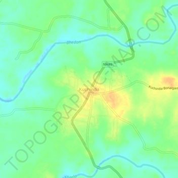
Name: Kuchinda topographic map, elevation, terrain.
Location: Kuchinda, Kochinda, Sambalpur, Odisha, 768222, India (21.72774 84.33064 21.76774 84.37064)
Average elevation: 755 ft
Minimum elevation: 712 ft
Maximum elevation: 814 ft
Thank you for supporting this site ❤️
Make a donation
Make a donation
Gear up for your next adventure:
As an Amazon Associate, this site earns from qualifying purchases at no extra cost to you.