
Make a donation
Gear up for your next adventure:
As an Amazon Associate, this site earns from qualifying purchases at no extra cost to you.
Biłgoraj topographic map
Click on the map to display elevation.
Make a donation
Gear up for your next adventure:
As an Amazon Associate, this site earns from qualifying purchases at no extra cost to you.
Biłgoraj
Biłgoraj lies in northern part of Sandomierz Basin, near Roztocze. The town is surrounded by Solska Forest, 20 km (12 mi) from Roztocze National Park. An average July temperature in Biłgoraj is 18 °C (64 °F), an average January temperature −2.8 °C (27.0 °F). The town is crossed by four small rivers: Biała Łada, Czarna Łada, Osa and Próchnica. Biłgoraj lies on the elevations ranging from 184 to 212 meters above sea level. The area of the town is 20 square kilometres (8 square miles), of which forests covers 9%. Built-up area stretches along eastern bank of the Biała Łada, for 5 km (3 mi) (north–south) and 3 km (2 mi) (west–east).
Make a donation
Gear up for your next adventure:
As an Amazon Associate, this site earns from qualifying purchases at no extra cost to you.
About this map
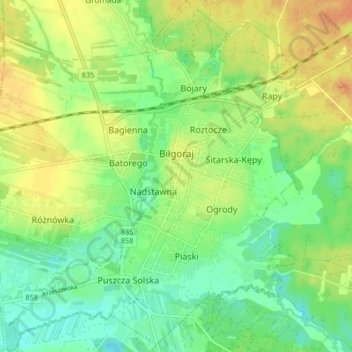
Name: Biłgoraj topographic map, elevation, terrain.
Location: Biłgoraj, Biłgoraj County, Lublin Voivodeship, 23-400, Poland (50.51312 22.67465 50.56491 22.74874)
Average elevation: 653 ft
Minimum elevation: 597 ft
Maximum elevation: 719 ft
Make a donation
Gear up for your next adventure:
As an Amazon Associate, this site earns from qualifying purchases at no extra cost to you.