
Sydenham topographic map
Click on the map to display elevation.
Sydenham
In the area where West Hill (later renamed Westwood Hill) and Crystal Palace Park Road raise in elevation and eventually meet, many fine villas were built in the latter half of the nineteenth century. Designed in revival architectural styles, fashionable at the time, most of the properties were three or four stories high and large enough to attract more affluent residents. UK Census records suggest that many employed one or more live-in domestic staff. One of the more unusual residential streets, due to its circular arrangement is Charleville Circus, subject of an in-depth One-place study. Upper Sydenham is also the location of the Sydenham Park allotments, the Sydenham electricity sub station which had a major fire in 2008 and the Sydenham Hill estate.
About this map
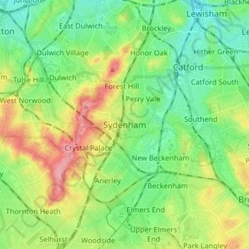
Name: Sydenham topographic map, elevation, terrain.
Location: Sydenham, Greater London, England, SE26 4PN, United Kingdom (51.38677 -0.09239 51.46677 -0.01239)
Average elevation: 148 ft
Minimum elevation: 20 ft
Maximum elevation: 390 ft
Other topographic maps
Click on a map to view its topography, its elevation and its terrain.
London Borough of Richmond upon Thames
United Kingdom > England > Greater London
Average elevation: 59 ft
Norwood Grove
United Kingdom > England > Greater London
After Anderson died, ownership passed to the Nettlefold family and subsequently to Frederick Nettlefold the brother of Joseph Nettlefold and a member of the family that founded the Nettlefolds Ltd. engineering firm which later became GKN. Nettlefold is commemorated, as a result of his charitable works, by a…
Average elevation: 190 ft
Pymmes Brook
United Kingdom > England > Greater London
Prior to the Anglian glaciation, a "proto-Mole-Wey" river was flowing northwards from the Weald and North Downs, through the "Finchley depression" and Palmers Green, to join the proto-Thames somewhere around Hoddesdon, at what is today an altitude of around 60 metres. It was this river which, during the course…
Average elevation: 135 ft