Geolocate

Dalston topographic map

Click on the map to display elevation.

About this map

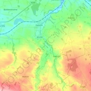
Name: Dalston topographic map, elevation, terrain.

Location: Dalston, Carlisle, Cumbria, England, United Kingdom (54.77615 -3.04799 54.86791 -2.90410)

Average elevation: 295 ft

Minimum elevation: 82 ft

Maximum elevation: 627 ft

Other topographic maps

Click on a map to view its topography, its elevation and its terrain.

Burgh by Sands

United Kingdom > England > Cumbria > Carlisle

Average elevation: 52 ft

Cold Fell

United Kingdom > England > Cumbria > Carlisle

Average elevation: 1,696 ft

River Eden

United Kingdom > England > Cumbria > Carlisle > Great Corby

Average elevation: 171 ft

Laversdale

United Kingdom > England > Cumbria > Carlisle > Laversdale

Average elevation: 151 ft

Trundley Wood

United Kingdom > England > Cumbria > Carlisle > Hethersgill

Average elevation: 167 ft

Carwinley

United Kingdom > England > Cumbria > Carlisle

Average elevation: 187 ft

Gear up for your next adventure:

🪶Multi‑Purpose Knife - Useful blade for camp and trail
📖Nature Tracking Books - Learn to track wildlife and terrain
🔊Portable Camp Speaker - Music and alerts at camp
🔭Telescopic Hiking Pole - Adjustable pole for hiking stability
🪶Camping Sleeping Pad - Comfortable sleeping pad for backpacking

As an Amazon Associate, this site earns from qualifying purchases at no extra cost to you.