
Town of Whitestown topographic map
Interactive map
Click on the map to display elevation.
About this map
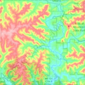
Name: Town of Whitestown topographic map, elevation, terrain.
Location: Town of Whitestown, Vernon County, Wisconsin, United States (43.63862 -90.67111 43.72633 -90.55231)
Average elevation: 1,053 ft
Minimum elevation: 817 ft
Maximum elevation: 1,371 ft
Vernon County trails, hiking, mountain biking, running and outdoor activities
Other topographic maps
Click on a map to view its topography, its elevation and its terrain.