
Arenberg topographic map
Click on the map to display elevation.
Arenberg
Koblenz-Arenberg ist ein Höhenstadtteil von Koblenz. Der 1970 eingemeindete Stadtteil liegt rechtsrheinisch oberhalb von Ehrenbreitstein und westlich der B 49 nach Montabaur. Arenberg ist der östlichste Koblenzer Stadtteil. Er ist seit dem 19. Jahrhundert ein katholischer Wallfahrtsort mit einer europaweit einzigartigen Landschaftsbilderbibel.
About this map
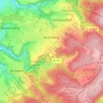
Name: Arenberg topographic map, elevation, terrain.
Average elevation: 784 ft
Minimum elevation: 318 ft
Maximum elevation: 1,148 ft
Other topographic maps
Click on a map to view its topography, its elevation and its terrain.
Koblenz
Deutschland > Rheinland-Pfalz > Koblenz
Koblenz liegt laut Angabe des Bundesamtes für Kartographie und Geodäsie auf 73 m ü. NHN. Das Deutsche Eck liegt bei 64,7 m Höhe. Die höchste vollständig im Stadtgebiet gelegene Erhebung ist mit 382 m der Kühkopf im Stadtwald. Die höchste Stelle des Stadtgebietes mit 385 m befindet sich auf der Grenze…
Average elevation: 787 ft