
Fork Union topographic map
Click on the map to display elevation.
About this map
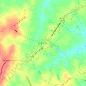
Name: Fork Union topographic map, elevation, terrain.
Location: Fork Union, Fluvanna County, Virginia, 23022, United States (37.74330 -78.28262 37.78330 -78.24262)
Average elevation: 367 ft
Minimum elevation: 259 ft
Maximum elevation: 482 ft
Fluvanna County trails, hiking, mountain biking, running and outdoor activities
Other topographic maps
Click on a map to view its topography, its elevation and its terrain.
Lake Monticello
United States > Virginia > Fluvanna County > Lake Monticello
Average elevation: 374 ft
Lake Monticello
United States > Virginia > Fluvanna County > Lake Monticello
Average elevation: 374 ft
Lake Monticello
United States > Virginia > Fluvanna County > Lake Monticello
Average elevation: 374 ft