
Mount Meron topographic map
Click on the map to display elevation.
Mount Meron
In 1965, an 84,000-dunam nature reserve was declared. An additional 1,199 dunams were declared part of the reserve in 2005. It is the highest reserve in Israel, at an altitude of 1,204 meters above sea level, and the largest reserve in the north of the country.
About this map
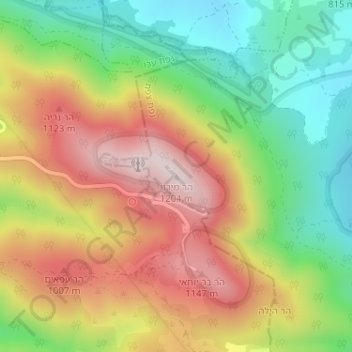
Name: Mount Meron topographic map, elevation, terrain.
Average elevation: 3,094 ft
Minimum elevation: 2,352 ft
Maximum elevation: 3,917 ft
Other topographic maps
Click on a map to view its topography, its elevation and its terrain.
Meron
Israel > North District > Merom HaGalil Regional Council
Meron is noted for its mountainous terrain and valleys. Among the local attractions are the Meron Vineyards. Meron is conducive to growing grapes for wine as a result of its 600-meter altitude and chalky soil. The vineyard was first planted in 2000 and is part of the Galil Mountain Winery, headquartered in…
Average elevation: 2,411 ft