
Reynisfjara Beach topographic map
Click on the map to display elevation.
About this map
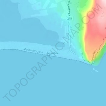
Name: Reynisfjara Beach topographic map, elevation, terrain.
Location: Reynisfjara Beach, Mýrdalshreppur, Southern Region, Iceland (63.40103 -19.10322 63.40776 -19.03512)
Average elevation: 75 ft
Minimum elevation: -16 ft
Maximum elevation: 781 ft
Other topographic maps
Click on a map to view its topography, its elevation and its terrain.
Vik
Vík í Mýrdal is the warmest place in Iceland, with an annual mean temperature of 5.3 °C (41.5 °F). Like most of coastal Iceland, Vík í Mýrdal has a subpolar oceanic climate (Koppen Cfc) with cold but not severe winters and cool, short summers. Its winters are among the warmest in Iceland, with an…
Average elevation: 348 ft
Vik
Vík í Mýrdal is the warmest place in Iceland, with an annual mean temperature of 5.3 °C (41.5 °F). Like most of coastal Iceland, Vík í Mýrdal has a subpolar oceanic climate (Koppen Cfc) with cold but not severe winters, and cool, short summers. Its winters are among the warmest in Iceland, with an…
Average elevation: 348 ft
Vik
Vík í Mýrdal is the warmest place in Iceland, with an annual mean temperature of 5.3 °C (41.5 °F). Like most of coastal Iceland, Vík í Mýrdal has a subpolar oceanic climate (Koppen Cfc) with cold but not severe winters and cool, short summers. Its winters are among the warmest in Iceland, with an…
Average elevation: 348 ft