
Thank you for supporting this site ❤️
Make a donation
Make a donation
Gear up for your next adventure:
As an Amazon Associate, this site earns from qualifying purchases at no extra cost to you.
Willinghusen topographic map
Click on the map to display elevation.
Thank you for supporting this site ❤️
Make a donation
Make a donation
Gear up for your next adventure:
As an Amazon Associate, this site earns from qualifying purchases at no extra cost to you.
Willinghusen
Willinghusen liegt in einem Wasserschutzgebiet. Eine Gefährdung für dieses Wasserschutzgebiet geht von den umliegenden Deponien aus; auch bei der Anhöhe Katzenberg sollen Giftstoffe vergraben worden sein.
Thank you for supporting this site ❤️
Make a donation
Make a donation
Gear up for your next adventure:
As an Amazon Associate, this site earns from qualifying purchases at no extra cost to you.
About this map
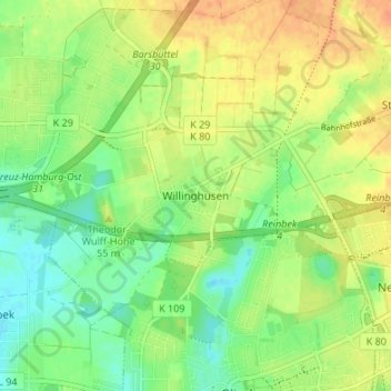
Name: Willinghusen topographic map, elevation, terrain.
Average elevation: 118 ft
Minimum elevation: 62 ft
Maximum elevation: 177 ft
Thank you for supporting this site ❤️
Make a donation
Make a donation
Gear up for your next adventure:
As an Amazon Associate, this site earns from qualifying purchases at no extra cost to you.