
Make a donation
Gear up for your next adventure:
As an Amazon Associate, this site earns from qualifying purchases at no extra cost to you.
Alacón topographic map
Click on the map to display elevation.
Make a donation
Gear up for your next adventure:
As an Amazon Associate, this site earns from qualifying purchases at no extra cost to you.
Alacón
Alacón is a municipality located in the province of Teruel, Aragon, Spain. According to the 2004 census (INE), the municipality had a population of 470 inhabitants, and is at an altitude of 704 meters (2,310 ft).
Make a donation
Gear up for your next adventure:
As an Amazon Associate, this site earns from qualifying purchases at no extra cost to you.
About this map
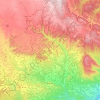
Name: Alacón topographic map, elevation, terrain.
Location: Alacón, Andorra-Sierra de Arcos, Teruel, Aragon, Spain (41.01021 -0.75309 41.08894 -0.65292)
Average elevation: 2,503 ft
Minimum elevation: 1,614 ft
Maximum elevation: 3,104 ft
Make a donation
Gear up for your next adventure:
As an Amazon Associate, this site earns from qualifying purchases at no extra cost to you.