Geolocate

Båstad topographic map

Click on the map to display elevation.

About this map
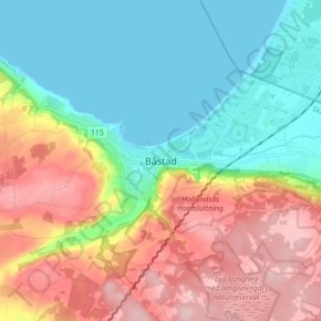
Name: Båstad topographic map, elevation, terrain.

Location: Båstad, Båstads kommun, Skåne County, 269 36, Sweden (56.38679 12.82072 56.46679 12.90072)

Average elevation: 259 ft

Minimum elevation: 0 ft

Maximum elevation: 666 ft

Other topographic maps

Click on a map to view its topography, its elevation and its terrain.
Vellinge kommun

Sweden > Skåne County

Average elevation: 26 ft

Klippans kommun

Sweden > Skåne County

Average elevation: 246 ft

Båstads kommun

Sweden > Skåne County

Average elevation: 118 ft

Gear up for your next adventure:

🏕️Family Camping Gear - Essentials for group camping trips
🧤Tactile Hiking Gloves - Keep hands warm while operating GPS and smartphone screens
⌚Solar GPS Watches - Advanced multisport watches with built-in topographic maps
🧭Pro Hiking Compasses - High-accuracy liquid-filled compasses for topographic orientation
🗺️Topographic Maps - Detailed topo maps for hiking, exploring and outdoor navigation

As an Amazon Associate, this site earns from qualifying purchases at no extra cost to you.