Geolocate

Levant topographic map

Click on the map to display elevation.

About this map

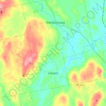
Name: Levant topographic map, elevation, terrain.

Location: Levant, Penobscot County, Maine, 04456, United States (44.84097 -69.06239 44.93805 -68.91337)

Average elevation: 197 ft

Minimum elevation: 85 ft

Maximum elevation: 390 ft

Penobscot County trails, hiking, mountain biking, running and outdoor activities

Other topographic maps

Click on a map to view its topography, its elevation and its terrain.

Lincoln

United States > Maine > Penobscot County > Lincoln

Average elevation: 272 ft

Houston Island

United States > Maine > Penobscot County > Winn

Average elevation: 243 ft

Carroll

United States > Maine > Penobscot County

Average elevation: 778 ft

Fairmont Park

United States > Maine > Penobscot County > Bangor

Average elevation: 148 ft

Meadow Brook

United States > Maine > Penobscot County

Average elevation: 325 ft

Gear up for your next adventure:

🍳Camping Cook Set - Complete cookware for outdoor meals
🔥Camping Stove - Portable stove for camping and backcountry cooking
🧦Merino Wool Socks - Moisture-wicking, blister-preventing socks for long treks
🦶Carbon Trekking Poles - Reduce knee impact on steep descents with ultra-light poles
🧴Hand Sanitizer - Keep hands clean while hiking

As an Amazon Associate, this site earns from qualifying purchases at no extra cost to you.