Geolocate

Honfleur topographic map

Click on the map to display elevation.

About this map

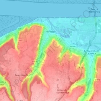
Name: Honfleur topographic map, elevation, terrain.

Location: Honfleur, Lisieux, Calvados, Normandy, Metropolitan France, 14600, France (49.38846 0.18375 49.42866 0.27544)

Average elevation: 184 ft

Minimum elevation: -10 ft

Maximum elevation: 413 ft

Other topographic maps

Click on a map to view its topography, its elevation and its terrain.

Omaha Beach

France > Normandy > Calvados > Vierville-sur-Mer

Average elevation: 69 ft

Juno Beach

France > Normandy > Calvados > Courseulles-sur-Mer

Average elevation: 13 ft

Rauray

France > Normandy > Calvados > Tessel

Average elevation: 348 ft

Escoville

France > Normandy > Calvados > Escoville > Escoville

Average elevation: 105 ft

Gear up for your next adventure:

🎒Waterproof Dry Bags - Keep your electronics and maps dry inside your pack
🚑Emergency Bivvies - Heat-reflective sleeping bags for survival situations
🛠️Backpacking Tool Kit - Essential toolkit for outdoor repairs
🧭GPS Watch Accessories - Bands and chargers for GPS watches
📻Weather Alert Radios - Stay informed of storm risks while off-the-grid

As an Amazon Associate, this site earns from qualifying purchases at no extra cost to you.