Geolocate

Town of Moriah topographic map

Interactive map

Click on the map to display elevation.

About this map

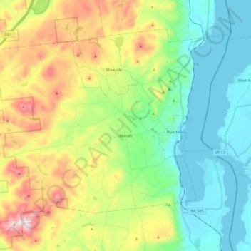
Name: Town of Moriah topographic map, elevation, terrain.

Location: Town of Moriah, Essex County, New York, United States (43.99052 -73.63535 44.11496 -73.41178)

Average elevation: 928 ft

Minimum elevation: 85 ft

Maximum elevation: 2,641 ft

Essex County trails, hiking, mountain biking, running and outdoor activities

Other topographic maps

Click on a map to view its topography, its elevation and its terrain.

Bitch Mountain

United States > New York > Essex County

Average elevation: 1,900 ft

Mount Marcy

United States > New York > Essex County > Town of Keene

Mount Marcy is the highest point in the Adirondack Mountains and the U.S. state of New York, with an elevation of 5,343.1 feet (1,628.6 m). It is located in the town of Keene in Essex County. The mountain is in the heart of the High Peaks Wilderness Area in Adirondack Park. Like the surrounding Adirondack…

Average elevation: 4,229 ft

Lake Eaton

United States > New York > Essex County > Town of Jay

Average elevation: 978 ft

Little Marcy

United States > New York > Essex County > Town of Keene

Average elevation: 4,140 ft

Pinnacle

United States > New York > Essex County

Average elevation: 2,621 ft

Mount Skylight

United States > New York > Essex County > Town of Keene

Average elevation: 4,055 ft

Mount Van Hoevenberg

United States > New York > Essex County

Average elevation: 2,221 ft

Jay Mountain

United States > New York > Essex County > Town of Jay

Average elevation: 2,621 ft

Keene Valley

United States > New York > Essex County > Town of Keene

Average elevation: 1,506 ft

Mount Adams

United States > New York > Essex County

Average elevation: 2,441 ft

Algonquin Peak

United States > New York > Essex County

Average elevation: 3,888 ft

Bear Mountain

United States > New York > Essex County

Average elevation: 1,198 ft

Whiteface Mountain

United States > New York > Essex County > Town of Wilmington

Whiteface Mountain is the fifth-highest mountain in the U.S. state of New York, and one of the High Peaks of the Adirondack Mountains. Set apart from most of the other High Peaks, the summit offers a 360-degree view of the Adirondacks and clear-day glimpses of Vermont and even Canada, where the skyscrapers of…

Average elevation: 3,576 ft

Pond Mountain

United States > New York > Essex County

Average elevation: 1,096 ft

Bitch Mountain

United States > New York > Essex County

Average elevation: 1,900 ft

Miller Mountain

United States > New York > Essex County

Average elevation: 538 ft

Keene

United States > New York > Essex County > Keene

Average elevation: 1,227 ft

Arbutus Pond

United States > New York > Essex County > Town of Newcomb

Average elevation: 1,736 ft

Lake Tear of the Clouds

United States > New York > Essex County

Far above the chilly waters of Lake Avalanche at an elevation of 4,293 feet lies summit water, a minute, unpretending, tear of the clouds — as it were — a lovely pool shivering in the breezes of the mountains and sending its limpid surplus through Feldspar Brook to the Opalescent River, the well-spring of…

Average elevation: 4,219 ft

Mineville

United States > New York > Essex County > Mineville

Average elevation: 1,224 ft

Minerva

United States > New York > Essex County > Minerva

Average elevation: 1,486 ft

Crown Point

United States > New York > Essex County > Crown Point

Average elevation: 262 ft