
Thank you for supporting this site ❤️
Make a donation
Make a donation
Gear up for your next adventure:
As an Amazon Associate, this site earns from qualifying purchases at no extra cost to you.
Arnbruck topographic map
Click on the map to display elevation.
Thank you for supporting this site ❤️
Make a donation
Make a donation
Gear up for your next adventure:
As an Amazon Associate, this site earns from qualifying purchases at no extra cost to you.
About this map
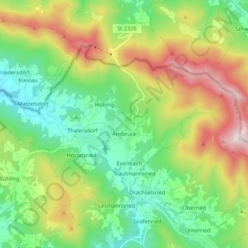
Name: Arnbruck topographic map, elevation, terrain.
Location: Arnbruck, Landkreis Regen, Bavaria, 93471, Germany (49.10265 12.91345 49.16644 13.06588)
Average elevation: 2,365 ft
Minimum elevation: 1,453 ft
Maximum elevation: 4,114 ft
Thank you for supporting this site ❤️
Make a donation
Make a donation
Gear up for your next adventure:
As an Amazon Associate, this site earns from qualifying purchases at no extra cost to you.