
Thank you for supporting this site ❤️
Make a donation
Make a donation
Gear up for your next adventure:
As an Amazon Associate, this site earns from qualifying purchases at no extra cost to you.
Tequepexpan topographic map
Click on the map to display elevation.
Thank you for supporting this site ❤️
Make a donation
Make a donation
Gear up for your next adventure:
As an Amazon Associate, this site earns from qualifying purchases at no extra cost to you.
About this map
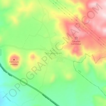
Name: Tequepexpan topographic map, elevation, terrain.
Location: Tequepexpan, Santa María del Oro, Nayarit, 63850, México (21.19488 -104.59055 21.23488 -104.55055)
Average elevation: 4,843 ft
Minimum elevation: 4,245 ft
Maximum elevation: 5,577 ft
Thank you for supporting this site ❤️
Make a donation
Make a donation
Gear up for your next adventure:
As an Amazon Associate, this site earns from qualifying purchases at no extra cost to you.
Other topographic maps
Click on a map to view its topography, its elevation and its terrain.