
Make a donation
Gear up for your next adventure:
As an Amazon Associate, this site earns from qualifying purchases at no extra cost to you.
La Yesca topographic map
Click on the map to display elevation.
Make a donation
Gear up for your next adventure:
As an Amazon Associate, this site earns from qualifying purchases at no extra cost to you.
La Yesca
Mountainous zones comprise 95% of the area. The main elevations are Sierra el Pinabete at 1,420 m, the Sierra Pajaritos with an elevation of 2,500 m and the Sierra de Álica with an elevation of 2,200 m.
Make a donation
Gear up for your next adventure:
As an Amazon Associate, this site earns from qualifying purchases at no extra cost to you.
About this map
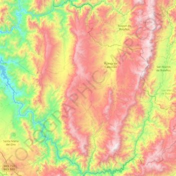
Name: La Yesca topographic map, elevation, terrain.
Location: La Yesca, Nayarit, Mexico (21.17643 -104.47617 22.00276 -103.72090)
Average elevation: 4,393 ft
Minimum elevation: 669 ft
Maximum elevation: 8,983 ft
Make a donation
Gear up for your next adventure:
As an Amazon Associate, this site earns from qualifying purchases at no extra cost to you.
Other topographic maps
Click on a map to view its topography, its elevation and its terrain.
Make a donation
Gear up for your next adventure:
As an Amazon Associate, this site earns from qualifying purchases at no extra cost to you.
Make a donation
Gear up for your next adventure:
As an Amazon Associate, this site earns from qualifying purchases at no extra cost to you.
Tepic
Located in the central part of the state, it stands at an altitude of 915 metres (3,002 ft) above sea level, on the banks of the Río Mololoa and the Río Tepic, approximately 225 kilometres (140 mi) north-west of Guadalajara, Jalisco. Nearby are the volcanoes of San Juan, Las Navajas, and Sangangüey. Tepic…
Average elevation: 3,022 ft
Make a donation
Gear up for your next adventure:
As an Amazon Associate, this site earns from qualifying purchases at no extra cost to you.
Make a donation
Gear up for your next adventure:
As an Amazon Associate, this site earns from qualifying purchases at no extra cost to you.
Tepic
Located in the central part of the state, it stands at an altitude of 915 metres (3,002 ft) above sea level, on the banks of the Río Mololoa and the Río Tepic, approximately 225 kilometres (140 mi) north-west of Guadalajara, Jalisco. Nearby are the extinct Sangangüey volcano and its crater lake. Tepic is…
Average elevation: 3,022 ft
Make a donation
Gear up for your next adventure:
As an Amazon Associate, this site earns from qualifying purchases at no extra cost to you.