Geolocate

Farlam topographic map

Click on the map to display elevation.

Farlam

Farlam was originally divided into two townships, East Farlam and West Farlam, with a combined population in 1811 of 672 inhabitants and 115 houses. Hallbankgate and Kirkhouse were two hamlets located within the township of East Farlam, the former four miles south east of Brampton, and the latter, where the church stands, half-a-mile east of the village. Milton was a small village in West Farlam and is now in Brampton parish. The whole parish has a high elevation and topographically is quite hilly with an area in 1847 of 5,680 acres.

Wikipedia (CC-BY-SA 3.0)

About this map

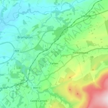
Name: Farlam topographic map, elevation, terrain.

Location: Farlam, Carlisle, Cumbria, England, United Kingdom (54.90964 -2.71009 54.94788 -2.56018)

Average elevation: 548 ft

Minimum elevation: 92 ft

Maximum elevation: 2,005 ft

Other topographic maps

Click on a map to view its topography, its elevation and its terrain.

Burgh by Sands

United Kingdom > England > Cumbria > Carlisle

Average elevation: 52 ft

Cold Fell

United Kingdom > England > Cumbria > Carlisle

Average elevation: 1,696 ft

River Eden

United Kingdom > England > Cumbria > Carlisle > Great Corby

Average elevation: 171 ft

Laversdale

United Kingdom > England > Cumbria > Carlisle > Laversdale

Average elevation: 151 ft

Trundley Wood

United Kingdom > England > Cumbria > Carlisle > Hethersgill

Average elevation: 167 ft

Carwinley

United Kingdom > England > Cumbria > Carlisle

Average elevation: 187 ft

Gear up for your next adventure:

🧷Carabiner Set - Durable clips for gear attachment
🛡️Insect Repellent - Protection against bugs during outdoor activities
🍳Camping Cook Set - Complete cookware for outdoor meals
📚USA Hiking Guide Books - Top trail guides and map books
🌎3D Topographic Globes - Raised relief globes for a tactile understanding of geography

As an Amazon Associate, this site earns from qualifying purchases at no extra cost to you.