
Make a donation
Gear up for your next adventure:
As an Amazon Associate, this site earns from qualifying purchases at no extra cost to you.
Gibbonsville topographic map
Click on the map to display elevation.
Make a donation
Gear up for your next adventure:
As an Amazon Associate, this site earns from qualifying purchases at no extra cost to you.
About this map
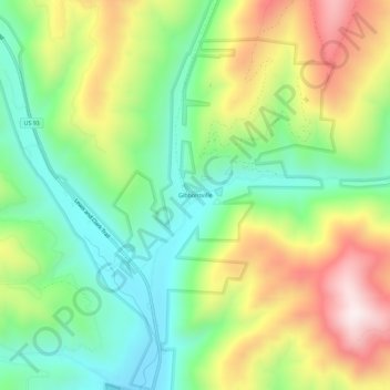
Name: Gibbonsville topographic map, elevation, terrain.
Location: Gibbonsville, Lemhi County, Idaho, 83463, United States (45.53548 -113.94313 45.57548 -113.90313)
Average elevation: 5,233 ft
Minimum elevation: 4,400 ft
Maximum elevation: 6,493 ft
Lemhi County trails, hiking, mountain biking, running and outdoor activities
Make a donation
Gear up for your next adventure:
As an Amazon Associate, this site earns from qualifying purchases at no extra cost to you.
Other topographic maps
Click on a map to view its topography, its elevation and its terrain.
Salmon
United States > Idaho > Lemhi County
Salmon is located at 45°10′41″N 113°54′10″W / 45.17806°N 113.90278°W / 45.17806; -113.90278 (45.178110, –113.902660). The elevation is 3,944 feet (1,202 m) above sea level.
Average elevation: 4,091 ft
Salmon
United States > Idaho > Lemhi County
Salmon is located at 45°10′41″N 113°54′10″W / 45.17806°N 113.90278°W / 45.17806; -113.90278 (45.178110, –113.902660). The elevation is 3,944 feet (1,202 m) above sea level.
Average elevation: 4,091 ft