
Make a donation
Gear up for your next adventure:
As an Amazon Associate, this site earns from qualifying purchases at no extra cost to you.
Gosau topographic map
Click on the map to display elevation.
Make a donation
Gear up for your next adventure:
As an Amazon Associate, this site earns from qualifying purchases at no extra cost to you.
Gosau
Gosau is situated along the Gosaubach stream in the Salzkammergut region. The center of the town is at an elevation of 767m (2,516'). 58.9% of the municipality is forested. At the southern end of Gosau there is a road leading to the Vorderer Gosausee, a lake with a view of the Dachstein.
Make a donation
Gear up for your next adventure:
As an Amazon Associate, this site earns from qualifying purchases at no extra cost to you.
About this map
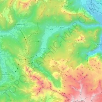
Name: Gosau topographic map, elevation, terrain.
Location: Gosau, Bezirk Gmunden, Upper Austria, 4824, Austria (47.47303 13.47537 47.63038 13.65163)
Average elevation: 4,383 ft
Minimum elevation: 1,647 ft
Maximum elevation: 9,514 ft
Make a donation
Gear up for your next adventure:
As an Amazon Associate, this site earns from qualifying purchases at no extra cost to you.