
Make a donation
Gear up for your next adventure:
As an Amazon Associate, this site earns from qualifying purchases at no extra cost to you.
Schwöb topographic map
Click on the map to display elevation.
Make a donation
Gear up for your next adventure:
As an Amazon Associate, this site earns from qualifying purchases at no extra cost to you.
About this map
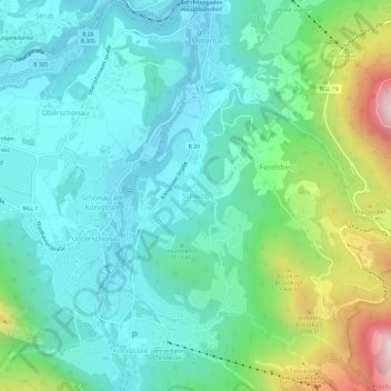
Name: Schwöb topographic map, elevation, terrain.
Average elevation: 2,526 ft
Minimum elevation: 1,775 ft
Maximum elevation: 4,905 ft
Make a donation
Gear up for your next adventure:
As an Amazon Associate, this site earns from qualifying purchases at no extra cost to you.
Other topographic maps
Click on a map to view its topography, its elevation and its terrain.
Nationalpark Berchtesgaden
Germany > Bavaria > Landkreis Berchtesgadener Land
Average elevation: 4,695 ft
Make a donation
Gear up for your next adventure:
As an Amazon Associate, this site earns from qualifying purchases at no extra cost to you.
Ramsau bei Berchtesgaden
Germany > Bavaria > Landkreis Berchtesgadener Land
Average elevation: 4,272 ft
Nationalpark Berchtesgaden
Germany > Bavaria > Landkreis Berchtesgadener Land
Average elevation: 4,695 ft
Make a donation
Gear up for your next adventure:
As an Amazon Associate, this site earns from qualifying purchases at no extra cost to you.
Untersberg
Germany > Bavaria > Landkreis Berchtesgadener Land
Several trails lead to the top, though most people prefer the Untersbergbahn cable car. Constructed over a period of over two years, and opening in April 1961, the eight and a half minute journey lifts passengers from the lower terminus at the village of Sankt Leonhard at 456 m (1,496 ft) over 1,320 m (4,330…
Average elevation: 2,615 ft
Listsee
Germany > Bavaria > Landkreis Berchtesgadener Land > Bad Reichenhall
Average elevation: 2,615 ft
Untersberg
Germany > Bavaria > Landkreis Berchtesgadener Land
Several trails lead to the top, though most people prefer the Untersbergbahn cable car. Constructed over a period of over two years, and opening in April 1961, the eight and a half minute journey lifts passengers from the lower terminus at the village of Sankt Leonhard at 456 m (1,496 ft) over 1,320 m (4,330…
Average elevation: 2,615 ft
Make a donation
Gear up for your next adventure:
As an Amazon Associate, this site earns from qualifying purchases at no extra cost to you.
Watzmann
Germany > Bavaria > Landkreis Berchtesgadener Land > Ramsau bei Berchtesgaden
Average elevation: 3,862 ft
Abtsdorfer See
Germany > Bavaria > Landkreis Berchtesgadener Land > Abtsdorf > Seethal
Average elevation: 1,447 ft
Make a donation
Gear up for your next adventure:
As an Amazon Associate, this site earns from qualifying purchases at no extra cost to you.