
Marktschellenberg topographic map
Click on the map to display elevation.
About this map
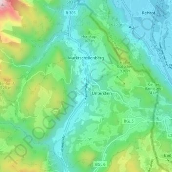
Name: Marktschellenberg topographic map, elevation, terrain.
Average elevation: 2,323 ft
Minimum elevation: 1,398 ft
Maximum elevation: 5,210 ft
Other topographic maps
Click on a map to view its topography, its elevation and its terrain.
Obersalzberg
Germany > Bavaria > Landkreis Berchtesgadener Land > Berchtesgaden > Untersalzberg I
Average elevation: 3,061 ft
Listsee
Germany > Bavaria > Landkreis Berchtesgadener Land > Bad Reichenhall
Average elevation: 2,615 ft
Oberjettenberg
Germany > Bavaria > Landkreis Berchtesgadener Land > Schneizlreuth
Average elevation: 2,598 ft
Untersalzberg I
Germany > Bavaria > Landkreis Berchtesgadener Land > Berchtesgaden
Average elevation: 2,487 ft
Mayerhofen
Germany > Bavaria > Landkreis Berchtesgadener Land > Laufen > Oberheining
Average elevation: 1,371 ft