
Make a donation
Gear up for your next adventure:
As an Amazon Associate, this site earns from qualifying purchases at no extra cost to you.
Batu Dam topographic map
Click on the map to display elevation.
Make a donation
Gear up for your next adventure:
As an Amazon Associate, this site earns from qualifying purchases at no extra cost to you.
About this map
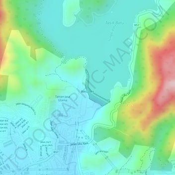
Name: Batu Dam topographic map, elevation, terrain.
Average elevation: 463 ft
Minimum elevation: 213 ft
Maximum elevation: 1,158 ft
Make a donation
Gear up for your next adventure:
As an Amazon Associate, this site earns from qualifying purchases at no extra cost to you.
Other topographic maps
Click on a map to view its topography, its elevation and its terrain.
Kampung Indian Settlement Batu Caves
Malaysia > Selangor > Selayang Municipal Council > Batu Caves
Average elevation: 223 ft
Kampung Melayu Pekan Rawang
Malaysia > Selangor > Selayang Municipal Council > Rawang
Average elevation: 157 ft
Make a donation
Gear up for your next adventure:
As an Amazon Associate, this site earns from qualifying purchases at no extra cost to you.
Kampung Sri Gombak Indah
Malaysia > Selangor > Selayang Municipal Council > Batu Caves
Average elevation: 276 ft
Make a donation
Gear up for your next adventure:
As an Amazon Associate, this site earns from qualifying purchases at no extra cost to you.
Kampung Laksamana
Malaysia > Selangor > Selayang Municipal Council > Batu Caves
Average elevation: 256 ft
Kampung Selayang Baru
Malaysia > Selangor > Selayang Municipal Council > Batu Caves
Average elevation: 240 ft
Kampung Indian Settlement Batu Caves
Malaysia > Selangor > Selayang Municipal Council > Batu Caves
Average elevation: 223 ft
Make a donation
Gear up for your next adventure:
As an Amazon Associate, this site earns from qualifying purchases at no extra cost to you.
Kampung Selayang Baru
Malaysia > Selangor > Selayang Municipal Council > Batu Caves
Average elevation: 240 ft
Kampung Gombak Utara
Malaysia > Selangor > Selayang Municipal Council > Gombak
Average elevation: 397 ft
Make a donation
Gear up for your next adventure:
As an Amazon Associate, this site earns from qualifying purchases at no extra cost to you.
Simpah Selatan
Malaysia > Selangor > Selayang Municipal Council > Batu Arang
Average elevation: 135 ft
Kampung Indian Settlement Batu Caves
Malaysia > Selangor > Selayang Municipal Council > Batu Caves
Average elevation: 223 ft
Kampung Selayang Indah
Malaysia > Selangor > Selayang Municipal Council > Batu Caves
Average elevation: 233 ft
Make a donation
Gear up for your next adventure:
As an Amazon Associate, this site earns from qualifying purchases at no extra cost to you.
Kampung Baru Batu Caves
Malaysia > Selangor > Selayang Municipal Council > Batu Caves
Average elevation: 226 ft
Make a donation
Gear up for your next adventure:
As an Amazon Associate, this site earns from qualifying purchases at no extra cost to you.
Kampung Indian Settlement Batu Caves
Malaysia > Selangor > Selayang Municipal Council > Batu Caves
Average elevation: 223 ft
Dark Cave (Closed)
Malaysia > Selangor > Selayang Municipal Council > Batu Caves
Average elevation: 240 ft
Make a donation
Gear up for your next adventure:
As an Amazon Associate, this site earns from qualifying purchases at no extra cost to you.
Kampung Indian Settlement Batu Caves
Malaysia > Selangor > Selayang Municipal Council > Batu Caves
Average elevation: 223 ft
Kampung Orang Asli Sungai Relang
Malaysia > Selangor > Selayang Municipal Council
Average elevation: 1,207 ft
Kampung Melayu Pekan Rawang
Malaysia > Selangor > Selayang Municipal Council > Rawang
Average elevation: 157 ft
Make a donation
Gear up for your next adventure:
As an Amazon Associate, this site earns from qualifying purchases at no extra cost to you.
Kampung Melayu Pekan Rawang
Malaysia > Selangor > Selayang Municipal Council > Rawang
Average elevation: 157 ft
Kampung Sungai Serai
Malaysia > Selangor > Selayang Municipal Council > Kampung Sungai Serai
Average elevation: 177 ft
Make a donation
Gear up for your next adventure:
As an Amazon Associate, this site earns from qualifying purchases at no extra cost to you.
Lower Sungai Tua Waterfall
Malaysia > Selangor > Selayang Municipal Council
Average elevation: 1,319 ft
Kampung Melayu Pekan Rawang
Malaysia > Selangor > Selayang Municipal Council > Rawang
Average elevation: 157 ft
Make a donation
Gear up for your next adventure:
As an Amazon Associate, this site earns from qualifying purchases at no extra cost to you.
Kampung Baru Batu Caves
Malaysia > Selangor > Selayang Municipal Council > Batu Caves
Average elevation: 223 ft
Kampung Selayang Indah
Malaysia > Selangor > Selayang Municipal Council > Batu Caves > Kampung Selayang Indah
Average elevation: 249 ft
Kampung Melayu Pekan Rawang
Malaysia > Selangor > Selayang Municipal Council > Rawang
Average elevation: 157 ft
Make a donation
Gear up for your next adventure:
As an Amazon Associate, this site earns from qualifying purchases at no extra cost to you.