Geolocate

Raglan topographic map

Click on the map to display elevation.

About this map

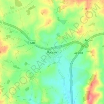
Name: Raglan topographic map, elevation, terrain.

Location: Raglan, Monmouthshire, Wales, NP15 2DR, United Kingdom (51.74505 -2.87406 51.78505 -2.83406)

Average elevation: 197 ft

Minimum elevation: 89 ft

Maximum elevation: 377 ft

Other topographic maps

Click on a map to view its topography, its elevation and its terrain.

Wye Valley

United Kingdom > Wales > Monmouthshire

Average elevation: 548 ft

Chepstow Castle

United Kingdom > Wales > Monmouthshire > Chepstow

Average elevation: 174 ft

Penallt

United Kingdom > Wales > Monmouthshire

Average elevation: 571 ft

Crucorney

United Kingdom > Wales > Monmouthshire

Average elevation: 974 ft

Blorenge

United Kingdom > Wales > Monmouthshire > Govilon

Average elevation: 1,293 ft

River Monnow

United Kingdom > Wales > Monmouthshire

Average elevation: 564 ft

Llanbadoc

United Kingdom > Wales > Monmouthshire

Average elevation: 256 ft

River Monnow

United Kingdom > Wales > Monmouthshire

Average elevation: 564 ft

Raglan Castle

United Kingdom > Wales > Monmouthshire > Raglan

Average elevation: 194 ft

Gear up for your next adventure:

🌐World Map Poster - Decorative world maps with topographic info
🔌Solar Panel Charger - Charge gear sustainably outdoors
📚Navigation Handbooks - Master the art of reading topographic maps and using a compass
🪶Thermal Camp Blanket - Extra warmth for cold nights
🔋Rechargeable Batteries - Power up your outdoor devices

As an Amazon Associate, this site earns from qualifying purchases at no extra cost to you.