Geolocate

Monroeville topographic map

Click on the map to display elevation.

About this map

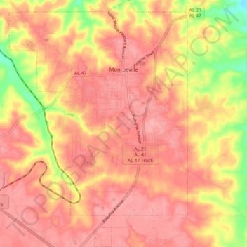
Name: Monroeville topographic map, elevation, terrain.

Location: Monroeville, Monroe County, Alabama, United States (31.47337 -87.36605 31.54592 -87.29755)

Average elevation: 358 ft

Minimum elevation: 167 ft

Maximum elevation: 443 ft

Monroe County trails, hiking, mountain biking, running and outdoor activities

Other topographic maps

Click on a map to view its topography, its elevation and its terrain.

Fountain

United States > Alabama > Monroe County

Average elevation: 171 ft

Axle

United States > Alabama > Monroe County

Average elevation: 305 ft

Claiborne

United States > Alabama > Monroe County

Average elevation: 135 ft

Peterman

United States > Alabama > Monroe County

Average elevation: 249 ft

Burnt Corn

United States > Alabama > Monroe County

Average elevation: 394 ft

Gear up for your next adventure:

Solar GPS Watches - Advanced multisport watches with built-in topographic maps
🥤Water Filter Bottle - All‑in‑one filter bottle for safe hydration
🧢Sun Protection Hats - Wide-brimmed and UPF-rated hats for high-altitude sun safety
🔦LED Headlamp - Bright and durable LED headlamp for night navigation
📌Outdoor GPS Map App - Apps and devices for digital topographic navigation

As an Amazon Associate, this site earns from qualifying purchases at no extra cost to you.